
History & Mythology
Pontinos, a hill full of stories
Again and again, people have looked at the same hill above Myloi and tried to understand what earlier generations left behind there.
First there was the hill.
Before there was a castle above Myloi, before Franks, Byzantines, Venetians and Ottomans fought over the Argolid, and long before anyone wrote down the names Kiveri or Chamires, Pontinos already rose above the springs of Lerna.
At 179 metres, Pontinos is not a high mountain. But it stands in a special place. Water rises at its foot, the Argolic Gulf lies on one side and on the other the plain stretches towards Argos and Nafplio. From the top you can survey land, sea and the roads to the coast.
That combination of water, fertile land and a wide view drew people to this area very early. At the foot of Pontinos grew Lerna, one of the most important prehistoric settlements of the Argolid. People lived here thousands of years before the medieval castle was built.
But the hill itself gained meaning too.
Athena on Pontinos
In antiquity a sanctuary of Athena Saitis stood on the summit of Pontinos.
The name Saitis refers to the Egyptian city of Sais, where the goddess Neith was worshipped; the Greeks identified her with Athena. According to an old tradition the sanctuary was founded by Danaos, the legendary king who came from Egypt to Argos. That belongs to mythology. That a sanctuary really stood on Pontinos, we know from a much later eyewitness.
According to tradition, the same hill was also the site of the house of Hippomedon, one of the legendary Seven against Thebes.
We do not know when these buildings were put up. We do know that they were old when Pausanias saw them.
Pausanias climbs the hill
Around the middle of the second century AD the Greek writer Pausanias travelled through the Argolid. He visited Lerna and described Pontinos. His words are special, because he describes a place we can still visit today.
He tells of the sacred grove at Lerna, of Mount Pontinos and of the water that flowed there. Then he writes that on the summit stood a sanctuary of Athena Saitis, and that the foundations of the house of Hippomedon could be seen there too.
But Pausanias did not find a living temple hill. For him, too, the past was already a ruin. Of the sanctuary of Athena only remains were left; of the house of Hippomedon he saw foundations.
Perhaps that is where the story begins that still continues today. Pausanias stood on Pontinos, looked at old stones and tried to understand who had put them there. Almost two thousand years later, we are really doing the same.
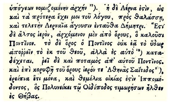
“Lerna is, as I said earlier in my account, by the sea, and here they celebrate a mystery in honour of Lernaean Demeter. There is a sacred grove, beginning at the mountain they call Pontinos. Mount Pontinos does not let the rainwater run off, but takes it in. From it flows a river, also called Pontinos. On the summit of the mountain is a sanctuary of Athena Saitis, now only ruins, and the foundations of the house of Hippomedon, who went to Thebes to avenge Polyneices, son of Oedipus.”
Centuries of silence
After Pausanias the summit of Pontinos falls silent. The sanctuary disappeared. The house of Hippomedon disappeared. We know hardly anything about what happened on the hill in the centuries that followed.
Until, in the Middle Ages, something entirely new appeared. Where an ancient sanctuary had once stood, a fortress rose.
Who built the first castle, and when exactly, is still not entirely clear. Wallace McLeod, who studied the castle in the twentieth century, thought it was probably built by the Franks in the fourteenth century. Later research by Ioannis Varalis, Georgios Tsekes and Konstantinos Bountouris changed that picture: on the basis of the masonry and the building technique they think the fortress may be older, possibly from the end of the twelfth or the first half of the thirteenth century.
So we do not know the castle's exact year of birth. But what was built was considerable.
The castle on Pontinos
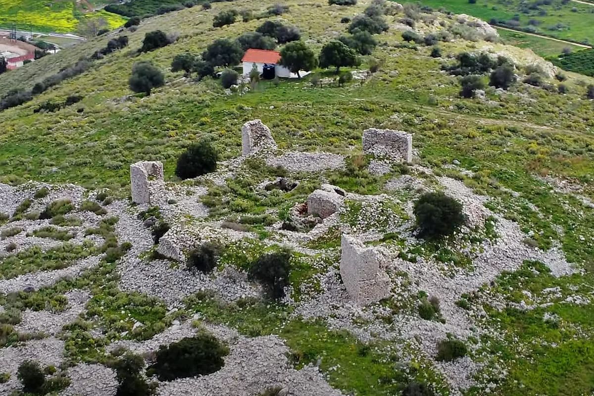
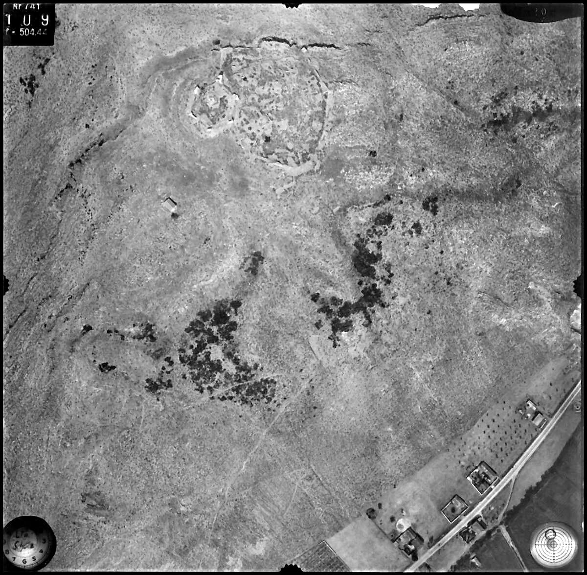
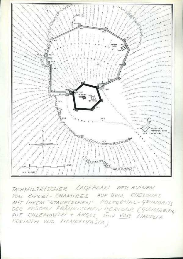
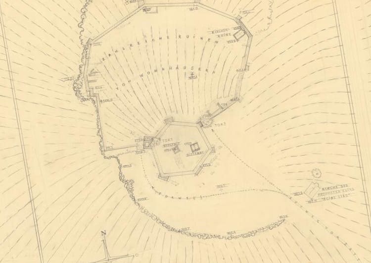
The medieval builders used the natural shape of the hill. An outer wall enclosed a large part of the summit, with several towers along it. Inside lay buildings and a small church.
Higher up was a second, stronger line of defence: a six-sided redoubt with the keep, the heavy main tower of the castle. On a besieged hill water was vital, so cisterns were built inside the fortress to store rainwater.
Anyone looking down from the walls saw roughly the same strategic landscape we see today: the coast, the Argolic Gulf, the plain and the roads towards Argos and Nafplio.
And somewhere inside those walls stood a little church.
The mysterious church
Its remains lie against the eastern wall of the outer ward. It was not a big church: the building was about nine metres long and 4.8 metres wide, with a semicircular apse on the east side.
Research revealed a remarkable detail. The area around the altar was slightly raised and paved with stone slabs. No traces were found of an Orthodox iconostasis or of a built Orthodox altar. That is why the researchers think this was probably a Latin, Catholic church.
We do not know what the church was called. That is one of the great riddles of Pontinos. But in a document from 1347 the church suddenly comes very close.
1347: a mass every day at Chamires
In 1347 Gautier VI de Brienne drew up his will. He was Lord of Argos and Nauplia and also bore the title of Duke of Athens. In that will he names his castle of Chamires.
Gautier ordered that a permanent chaplaincy be maintained there. The priest had to live in the castle and say mass every day. Gautier also set aside money for books, chalices and other things the chapel needed.
For the first time this lets us imagine daily life behind the walls. There were soldiers and inhabitants, but there was also a priest. There were service books and chalices. Mass was said every day.
It is tempting to identify the little church whose foundations we see today directly with the chapel in Gautier's will. That is quite possible, but it is not fully proven. Even the identification of Chamires with the castle of Kiveri on Pontinos still leaves some questions open, so some caution is needed.
What is certain is that a probably Latin church stood inside the castle, and that in the fourteenth century a Latin lord paid for a permanent chapel in his castle of Chamires. And we still do not know to which saint that church was dedicated.
From Franks to Venetians
At the end of the fourteenth century the political map changed again. In 1388 Marie d'Enghien, heiress of the Brienne family's possessions in the Argolid, sold her rights to Argos and Nauplia to the Republic of Venice.
The handover was anything but smooth. The Despot of Mystras seized the castles first, and only in 1394 did Venice actually gain control of the area. The Argolid had become part of the great struggle between Byzantines, Franks, Venetians and, in the end, Ottomans.
In the fifteenth century the castle on Pontinos gradually lost its importance. After the Venetian–Ottoman war of 1463–1479 the fortress was not rebuilt. The priest disappeared. The daily masses stopped. Roofs collapsed and walls began to crumble.
Pontinos became a hill of ruins once more.
1825: a defensive position once more
Centuries later the area became a battlefield again. During the Greek War of Independence, in 1825, the troops of Ibrahim Pasha advanced through the Peloponnese. At Myloi, Greek fighters tried to stop them from reaching Nafplio.
General Makriyannis fortified the mills and the village at the foot of Pontinos. The old fortress had been a ruin for centuries, but the reason why the medieval builders had chosen this very spot still held: whoever controlled it held a strategic position between the coast, the plain and Nafplio.
Buchon sees a different castle
In the nineteenth century travellers and scholars arrived who came not to defend Pontinos but to understand its past. One of them was the French historian Jean-Alexandre Buchon.
What he saw must have been more impressive than what remains today. Before 1841 he wrote that the great keep at the heart of the fortress was still standing several storeys high. Much of it has disappeared since.
That is what makes old travel accounts so valuable. They show not only what once stood here, but also how much has been lost in the past two hundred years.
1958: McLeod starts measuring
A decisive moment came in 1958 and 1959. Down at the foot of Pontinos, the famous prehistoric settlement of Lerna was being excavated. Meanwhile the archaeologist Wallace E. McLeod turned his attention to the medieval fort on the summit.
He walked along the walls, measured towers, examined the cisterns and drew a plan of the fortress. He recorded the little church with its apse too. In 1962 he published his research under the title “Kiveri and Thermisi”.
For the first time the castle was described systematically as a medieval monument. But scholarship does not stand still.
A new generation looks again
Decades later Ioannis Varalis, Georgios Tsekes and Konstantinos Bountouris looked at the same walls again, and their research led to new conclusions.
Among other things they studied the building technique, the masonry and the relationship between the different parts of the fortress. This led them to suspect that the castle is considerably older than McLeod had thought.
The little church also received fresh attention. The layout of the sanctuary, and the absence of certain features you would expect in an Orthodox church, led to the interpretation that it was probably a Latin church. Their results were presented at a scholarly conference in 2011.
More than fifty years after McLeod, the same ruin turned out to have something new to tell.
2024: signposts and QR codes
In recent years something changed on and around Pontinos once more. The Ephorate of Antiquities of Argolida, the archaeological service of the Greek Ministry of Culture, worked on a larger project to make Lerna and the surrounding historic landscape more accessible. Not only the famous prehistoric site was involved: Myloi, Pontinos and the other monuments in the area became part of the story.
Walking routes were laid out, one of them leading towards Pontinos and linking several historic places around Myloi. Along these routes wooden signposts and information boards with QR codes appeared. Through those codes walkers can read about the monuments and the history of the area on their phones.
On 26 May 2024, during the nationwide Green Cultural Routes events, the Ephorate presented the digital application. For the first time, a visitor no longer needed to carry Pausanias, a nineteenth-century travel account or an archaeological journal up the hill to understand what they were seeing.
The hill had begun to show its visitors the way.
2026: Visit Myloi looks at Pontinos again
And that brings us to the latest chapter. For Visit Myloi we looked at Pontinos again: not only at the castle, but at the whole history of the hill.
We came to Pausanias and his description of Athena Saitis. To the legend of Hippomedon. To the riddle of Chamires. To Gautier de Brienne and his priest who had to say mass every day. To the small nameless church inside the walls. To Buchon, who still saw the keep standing. To McLeod, who measured the ruin. To the Greek archaeologists who held his conclusions up to the light again. And finally to the new walking routes and QR codes that now lead visitors across the same hill.
This page is the newest milestone in a long series of attempts to understand Pontinos. Not because it is the last word on the hill. On the contrary.
We still do not know exactly where the sanctuary of Athena Saitis stood. We do not know what the little medieval church was called. We do not know with absolute certainty when the first stone of the castle was laid. Perhaps some of the answers still lie beneath our feet.
But that is exactly what draws people to Pontinos. Almost two thousand years ago Pausanias came here and looked at the remains of people who had lived on this hill centuries before him. In the nineteenth century Buchon did the same. In the twentieth century McLeod did it again, and after him the Greek archaeologists. Since 2024 signposts and QR codes lead new visitors to the hill. And in 2026 Visit Myloi adds its own chapter to that history.
Every generation looks at Pontinos again. Every generation discovers a little more. And the hill still keeps part of its story.
Source: Pausanias 2.36.8; J.-A. Buchon (before 1841), via Ephorate of Antiquities of Argolida, argolisculture.gr; W. E. McLeod, ‘Kiveri and Thermisi’, Hesperia 31 (1962) 378–392; A. Bon, La Morée franque (1969); K. Andrews, Castles of the Morea (1953); I. Varalis, K. Bountouris, G. Tsekes (2011), via Argoliki Vivliothiki (2026); will of Gautier de Brienne (1347); Ministry of Culture, Green Cultural Routes 2024; text: Visit Myloi (2026)