
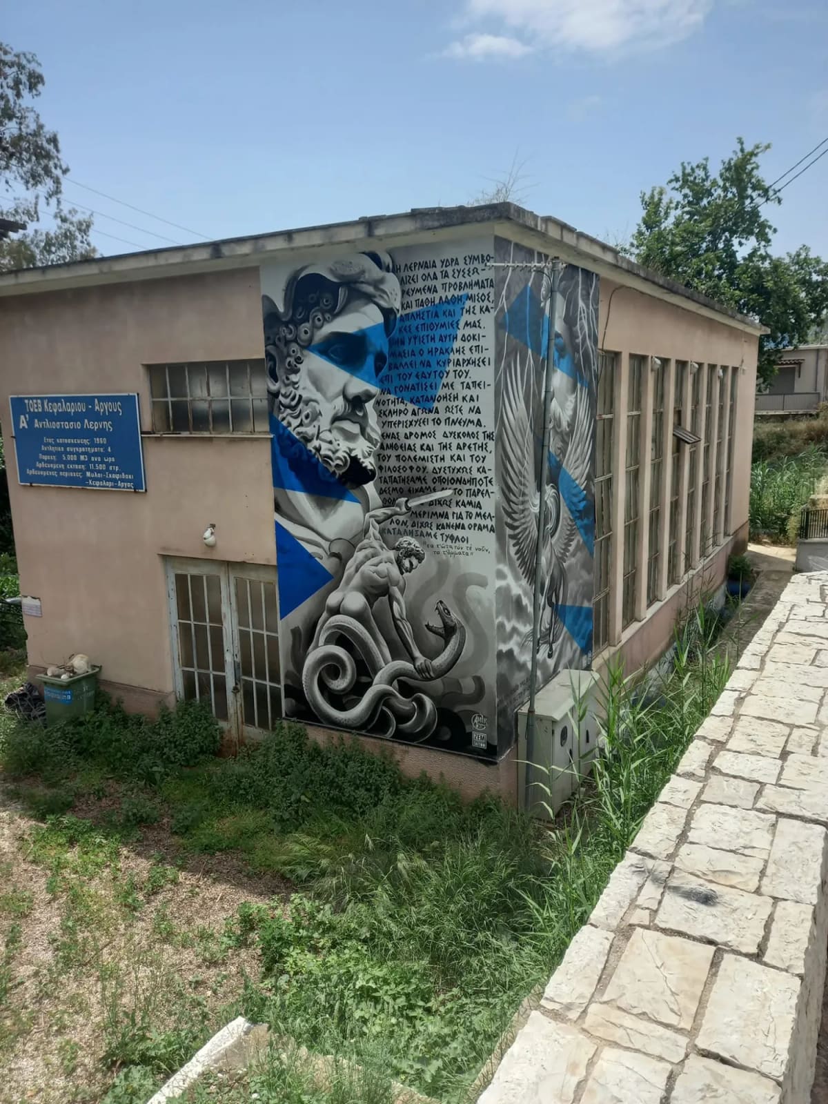
Drive south from Argos and, just before Myloi, you pass a low pink building with tall windows. On its wall Heracles is fighting the Hydra. Almost nobody stops. Yet this is where a story thousands of years long has, for now, arrived. Everything Myloi is, from its first houses to its name, began with one thing: a spring that never runs dry.
Water from the mountains
The springs of Lerna rise at the foot of Pontinos, the bare hill above the village. The water travels a long way. It sinks into the ground on the high plateaus of Arcadia, around Tripoli and Stymfalia, runs underground through the limestone and surfaces again here. The same karst system also feeds the spring of Kefalari near Argos and the undersea springs of Anavalos near Kiveri.
What makes Lerna special is that the spring rises about one metre above sea level and flows all year round, on average around a thousand litres a second. Kefalari often dries up in September. Lerna does not.
The first people and the first stories
That reliable water drew the first farmers here in the Neolithic. On a low rise by the springs, generation after generation built houses on the remains of the last. That is how the settlement mound of Lerna grew, with the famous House of the Tiles in the Early Bronze Age.
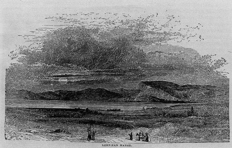
The ancient Greeks gave the water a mythology of its own. Poseidon was said to have made the springs gush for Amymone, daughter of Danaus. In the marsh they formed lived the Hydra that Heracles killed. And beside the springs lay the Alcyonian Lake, said to have no bottom.
The mills: how Myloi got its name
After 1212, under the Franks, the first watermills were built at Lerna. They ground grain using the power of the spring water.
After 1687 the Peloponnese came under Venice, and the Venetians greatly expanded the mills:
- they built large, connected vaulted granaries;
- they fitted the mills with new grinding machinery;
- in 1698 they also built a gunpowder workshop driven by the water;
- around the whole complex, the Afentiki Myli ("the masters' mills"), they built a stone dam with corner towers. It formed an artificial lake that collected the water of the Lerna springs and the Pontinos stream.
The mills supplied Nafplio with flour. Houses for the millers and their workers grew up around them, and farmers looking for safety moved there too. So a settlement formed: the Watermills of Lerna. That is where today's village gets its name: Myloi, "mills".
Under the Ottomans the mills stayed in use. From 1715 a small Turkish guard protected the millers. The mills belonged first to the Kapudan Pasha and later to the Bey of Nafplio. The British traveller William Leake saw two groups of mills in 1806:
- one group was driven by the springs at the foot of Pontinos;
- the other by the water from the lake of Amymone, right by the sea, next to a small landing place with storehouses.
In 1810 the Frenchman Barbié du Bocage counted six.
1825: the battle at the mills
Because the mills fed Nafplio and guarded the road south, they were strategic. On 13 June 1825 a few hundred Greeks under Makriyannis, Ypsilantis and Mavromichalis defended the mills against the army of Ibrahim Pasha, and held them.
After independence (1830) some mills kept turning. Even in the 1890s the Scottish scholar James Frazer still saw a mill "on the shore", with a large share of the spring water still led to it.
Railway, marsh and archaeologists
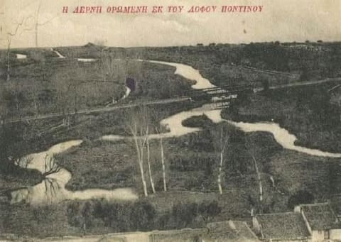
In 1886 the railway from Argos reached Myloi. From 1892 it continued into the mountains towards Tripoli. Railway and main road were squeezed between the foot of Pontinos and the springs.
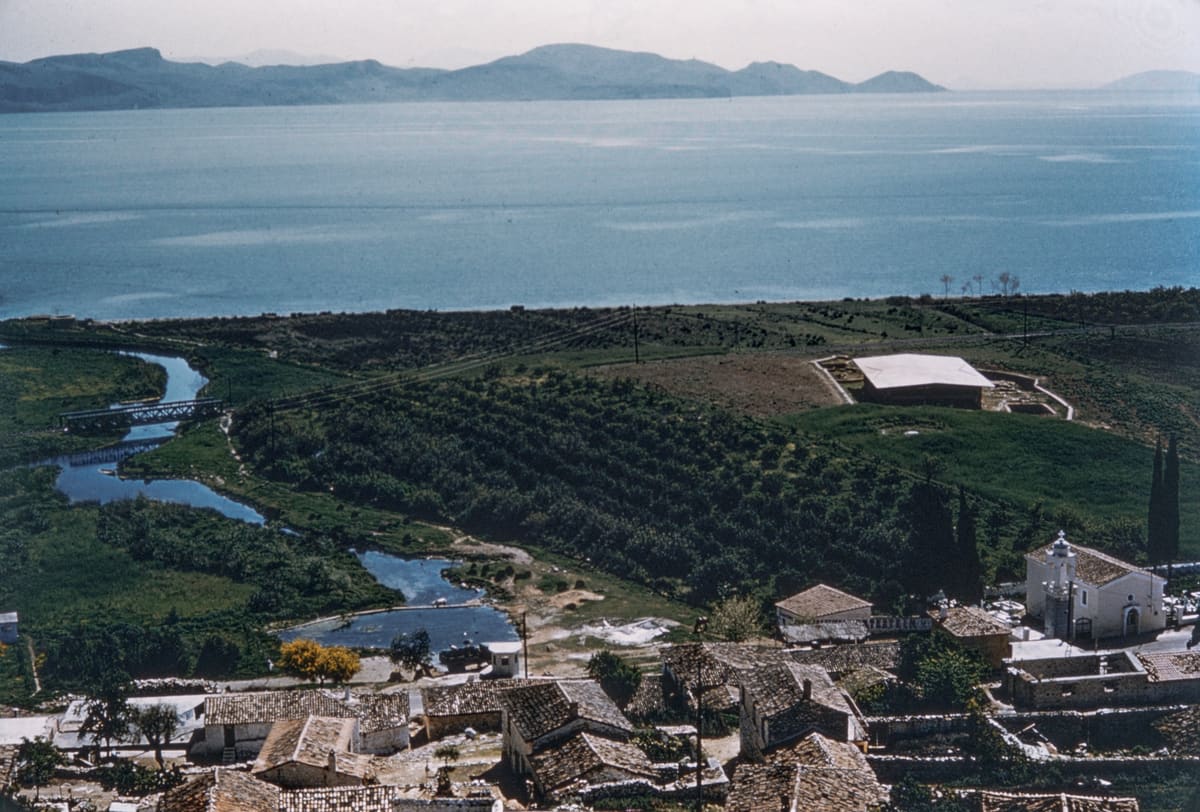
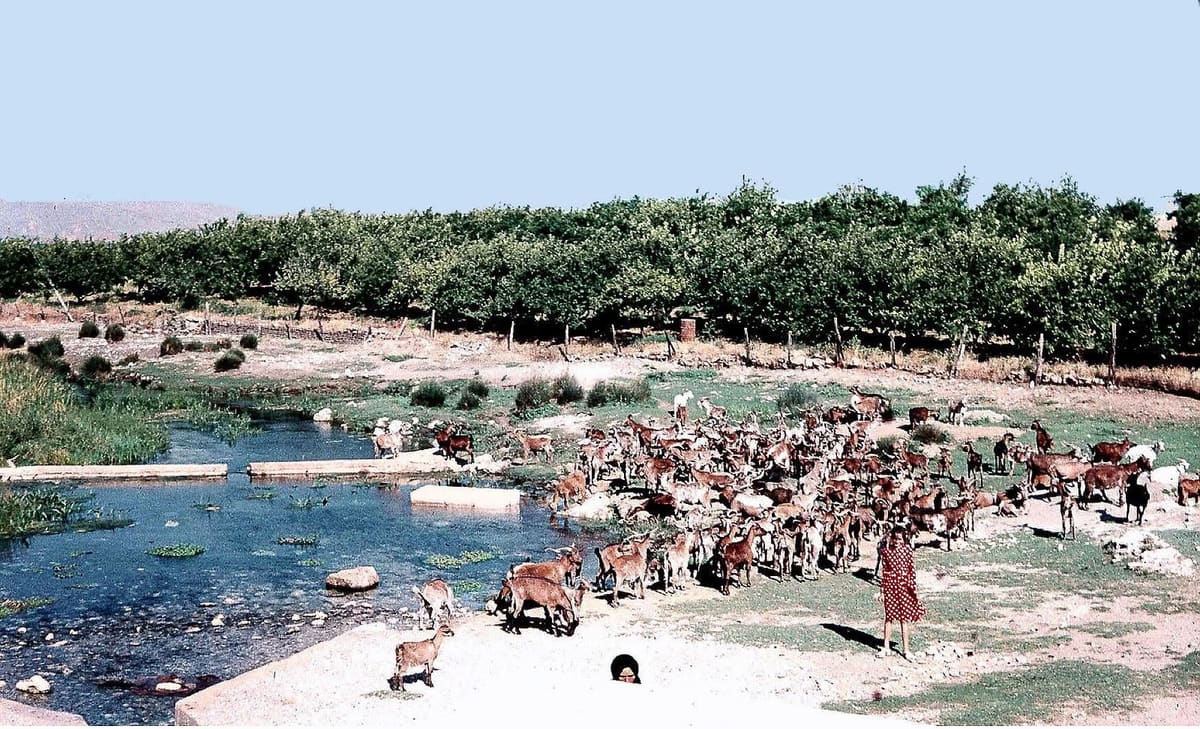
In the 1950s the American John L. Caskey excavated Lerna. He described the mound as lying on the south bank of "the stream Amymone, which runs its short course from the Lernaean spring to the Gulf". Photographs from that time still show marshes, the stream, orchards and grain fields. This is what it looked like just before everything changed.
1960: from mill to pump
At the end of the 1950s the water balance of the Argive plain tipped over:
- until 1958 less groundwater was pumped than the rain put back;
- after that wells sprang up everywhere for the growing citrus and fruit farming;
- the groundwater dropped, seawater pushed inland, and fields turned salty and were abandoned.
Around 1960 three ministries set up a committee with the UN's FAO. The answer of the day: the big springs, Kefalari and Lerna, should irrigate the plain.
So in 1960, right next to the main spring, the Α' Αντλιοστάσιο Λέρνης was built: the first pumping station of Lerna. According to the sign on the wall:
- 4 pumps;
- 5,000 m³ of water an hour, about as much as the spring itself delivers;
- to irrigate 11,500 stremmata (about 1,150 hectares) in Myloi, Skafidaki, Kefalari and Argos.
This is how it works: the station pushes the water through three large pipes straight up the side of Pontinos to a small water tower. From there a level channel runs along the hillside, just above the houses of Myloi. One branch heads south towards Kiveri, the other north towards Kefalari. The houses below draw water from it for their gardens, and side branches water the orange groves.
For centuries the water had run downhill to turn mills. Now it was pumped uphill to grow orchards. The mills had handed their job over to the pump.
Then (about 1700–1900): the water runs downhill
- The springs of Lerna at the foot of Pontinos
- The mill lake behind the Venetian dam with its corner towers
- A watermill
- Vaulted storehouses by the landing place
- The water flows to the sea
Since 1960: the water is pumped uphill
- The spring and the spring pond
- The 1960 pumping station
- Three rising mains up the slope
- The small water tower
- The level channel along the hillside, running north (Kefalari, Argos) and south (Kiveri), with branches to the gardens
- Citrus groves
- The underground drinking-water main to Nafplio and Argos
- What is left flows to the sea
The station belongs to the ΤΟΕΒ Κεφαλαρίου–Άργους, the local irrigation board.
Water for the towns
Soon the water of Myloi was also flowing from taps across the region:
- early 1960s: Nafplio takes its drinking water from the Amymone spring in Myloi, through an underground pipeline;
- 1963–1966: the agricultural service tries to recharge the groundwater with winter water from Lerna and Kefalari through some 60 wells (abandoned in 1967–68);
- 1967–1972: because Lerna and Kefalari are nowhere near enough, the undersea springs of Anavalos near Kiveri are tapped. Their main canal has a 30,000 m³ balancing reservoir on the edge of Myloi;
- 1988: Nafplio also starts taking water from the Lerna spring;
- 2003: Argos gets its drinking water from Lerna too.
A spring under pressure
Meanwhile more and more boreholes were drilled around the springs. Around 2009 a geologist counted some 570 in the Myloi–Skafidaki–Kefalari area. The old shared networks fell into neglect.
- 2008: in summer the spring delivers less than 400 m³ an hour.
- 2013: a water management plan proposes moving the cemetery above the spring and housing the scattered pumps at the spring inside the 1960 station building. In 2020 the regional council notes that this has not happened.
- August 2025: the spring that never ran dry "gives not a drop of water". The pumps for Nafplio and Argos stop.
- June 2026: after a wet winter the springs are back at about 65%.
And now: Heracles on the wall
That is how the pink building of 1960 stands today: a pumping station at the place where it all began. On its walls artists, among them ZEM tattoo from Nafplio, have painted Heracles and the Hydra. The mural has been there since at least June 2025. The text beside it reads like a warning. The Hydra stands for our own greed and mistakes, and "we have trampled every bond with the past, without vision, and have ended up blind". Below it is a line from Sophocles: blind in your ears, your mind and your eyes.
It is hard to think of a better message for this spot. The Hydra grew two new heads for every one that was cut off. At the spring of Lerna, every solution brings a new problem.
See it for yourself: a short walk past 800 years of waterworks
- The Venetian dam along the Myloi shore. A good stretch of the mill dam survives, recognisable by its careful masonry and hard mortar.
- Remains of the millers' buildings along the old Argos–Tripoli road through the village.
- The 1960 pumping station on the Argos–Tripoli road, with the mural. The spring pond lies behind it.
- The springs of Lerna and the church of Agios Dimitrios, about a hundred metres further south.
- The three rising mains and the channel on the slope of Pontinos, above the village.
- The excavation of Lerna, where it all began.
Sources
- Ephorate of Antiquities of Argolida, «Τείχος της Βενετικής Περιόδου» and «Αρδευτικό έργο Ανάβαλου» (2023): argolisculture.gr.
- W. M. Leake, Travels in the Morea II (1830), pp. 472–473; J. G. Frazer, Studies in Greek Scenery, Legend and History, ch. XXXIV; J. L. Caskey, Hesperia 23 (1954), pp. 3–4.
- R. Koch Piettre, "Invoking the water of Lerna", Les Études classiques 87 (2019), p. 301 (citing Barbié du Bocage, 1810): lesetudesclassiques.be.
- K. Gkonis & D. Basiakos, Σύλληψη πηγών Αναβάλου Αργολίδας, diploma thesis, NTUA, 1978: itia.ntua.gr.
- P. Ntontos, articles on the water of the Argolid (2009, 2011); Αναγνώστης (2021, 2026); Αργολικές Ειδήσεις (August 2025).
- River Basin Management Plan for the Eastern Peloponnese GR03 (2013); Peloponnese Regional Council, decision 75/2020: diavgeia.gov.gr; Ministry of Agriculture, reply to Parliament (2018).
- The information sign on the pumping station (photo Visit Myloi, 2026).
Do you know more about the building of the pumping station around 1960, the old mills or the mural? Or do you have photos? Let Visit Myloi know.